Large-scale Hydrography and Circulation of the Red Sea
A Collaboration between King Abdullah University of Science and Technology (KAUST) and the Woods Hole Oceanographic Institution (WHOI), Amy Bower PI
The Red Sea, which connects the Mediterranean Sea with the Indian Ocean, is an ocean basin of local, regional and global significance for human activities. It is fringed by extensive coral reefs, many in pristine condition, that provide critical habitat for marine life, support several important fisheries and attract tourists. One of the World’s most important shipping route between North America, Europe and Asia passes through the Red Sea, and it includes the largest commercial shipping port in the Middle East, Jeddah City.
In spite of its economic and environmental importance, our knowledge of the oceanographic conditions in the Red Sea, and the physical processes that drive it, are at this point rudimentary. We know that the Red Sea is relatively unique in that large amounts of fresh water are transferred from the ocean to the overlying atmosphere (about 2 meters per year) through evaporation. This leads to the formation of a hyper-saline, dense water mass, Red Sea Water (RSW) that escapes from the Red Sea into the Indian Ocean as a dense overflow through Bab al Mandeb. But the details of the circulation within the Red Sea itself and its variability on time scales from diurnal to interannual are largely unknown, due mainly to the paucity of oceanographic and meteorological observations.
A few oceanographic numerical models have used basic information on large-scale winds, evaporation and heating to predict the circulation of the Red Sea, but the available data are insufficient to verify the model results. Furthermore, such models have not previously been designed to resolve the circulation along the coast of Saudi Arabia. We expect that regional wind and evaporation patterns, surface gravity waves, “internal” waves, instabilities of large-scale currents, rectification of tidal currents, bathymetric steering and other processes are important in setting the local circulation in the coastal region.
To significantly improve our understanding of the hydrogrpahy and circulation of the Red Sea, and to provide the first comprehensive undersanding of the physical oceanography of the Red Sea, we are conducting repeated large-scale hydrographic and current surveys to document seasonal and interannual variability in water mass properties and currents throughout most of the Red Sea coastal waters off Saudi Arabia. These exploratory surveys would represent the first systematic mapping of the physical characteristics of the Saudi coastal waters and will be used to determine seasonal variability and the most appropriate sites for a coastal observing network.
Experts pitch in to help ministry study algae patch
Will test toxicity and threat of blooms
By Emmanuelle Landais, Senior Reporter
Published: December 30, 2010
Dubai: Researchers, in public health issues relating to harmful algal blooms, are in the UAE to assist the Ministry of Environment and Water test the toxicity of an algae patch which emerged off the East Coast in early December.
Shellfish from various marine ecosystems have also been put under the microscope in preliminary studies as crabs and other crustaceans are most prone to absorb toxins from red tide blooms.
Water and shellfish samples were taken from twelve locations including mangroves, reefs and shallow waters between December 12 and 17 to monitor their levels of toxicity and limit their distribution, in due course, to local fish markets.
The area of dense phytoplankton has not been declared as a harmful algal blooms.
However, the surveys are part of the UAE's national action plan to track and monitor such blooms, and maintain food security in the country, a statement from the Ministry of Environment said.
The ministry added that all means to control the phytoplankton are being used. The worst harmful algal bloom occurred in 2008 and lasted several months putting the fishing community under great financial duress after they were banned from fishing.
The Regional Organization for the Protection of the Marine Environment (ROPME) is also monitoring the patch by satellite.
Preparation
Dr Donald Anderson, a senior scientist in the Biology Department of the Woods Hole Oceanographic Institution in the US is leading the research in the UAE and is providing the ministry with technical advice on the preparation and implementation of programmes of the National Plan.
The possible development of the algal bloom is being assessed with a digital modelling programme and the use of remote sensing technology.
A criterion to protect fish farms is also being put in place. Ebrahim Al Jamali, director of the Ministry of Environment and Water's Marine Research Center announced last week that the ministry is conducting growth trials of 24 species of corals from the Arabian Gulf and Sea of Oman in the hope of one day rehabilitating existing reefs, and creating new ones.
Wednesday, December 29, 2010
Winter Storm in the Northeastern United States
Image acquired December 28, 2010
A severe winter storm dropped up to 32 inches (80 centimeters) of snow on parts of the northeastern United States in late December 2010. The two-day blizzard brought especially heavy snow to parts of New York, New Jersey, Connecticut, and Massachusetts, where gusts up to 80 miles (130 kilometers) per hour struck Cape Cod. Airlines canceled hundreds of flights, and tens of thousands of residents lost power. Ambulances stranded in snow-clogged streets forced New York City 911 dispatchers to resort to triage.
The Moderate Resolution Imaging Spectroradiometer (MODIS) on NASA’s Terra satellite captured this natural-color image of the northeastern United States and part of Canada on December 28, 2010. Snow and clouds blend rather seamlessly, but can be distinguished by their different textures. The wide swath of uniform white that extends from Michigan and Ontario toward the southeast is a cloudbank. Under clear skies, snow cover from the storm creates a mottled appearance across New England and southeastern Canada. Farther south, the snow appears to have missed much of central Pennsylvania.
As skies cleared over the northeastern United States, some residents enjoyed sledding and snowball fights while others endured backaches from snow shoveling. Thousands of airline passengers, meanwhile, awaited flights home from their holiday travels.
References
Baker, B., Moskowitz, E. (2010, December 29). Oh, what a beautiful day. Boston Globe. Accessed December 29, 2010.
A lemon shark caught by a charter fisherman off Key West, Florida. | Sue Cocking/Miami Herald/MCT
By Renee Schoof | McClatchy Newspapers
WASHINGTON — Congress on Tuesday passed legislation to better protect sharks, creatures that swam the oceans before the age of dinosaurs but now are being killed by the millions for their fins, a delicacy used in a traditional Chinese soup.
Conservationists called the measure a major step to save a species in trouble. They estimate that 73 million sharks are killed annually to support the shark fin trade, and that 30 percent of the world's species are threatened or nearly threatened with extinction. The loss of too many top predators can disrupt the balance of the populations of other species.
The Senate passed a bill, sponsored by Sen. John Kerry, D-Mass., on Monday, and the House of Representatives passed its version with the same language Tuesday, sending it to the president's desk for his signature. Supporters anticipate that he'll sign it.
The legislation requires that sharks caught legally must be landed with fins attached in all U.S. waters. Regulations already had banned cutting off the fins and dumping the bodies in the Gulf of Mexico and the Atlantic, but not in the Pacific. The requirement that the fins remain on the bodies for inspection gives fisheries management officials a clearer picture of how many sharks and what species were caught.
The legislation also closes a loophole in a previous law that allowed fins to be cut off at sea and transferred to non-fishing vessels.
"Our oceans have reached a tipping point, and sharks are essential to keeping them healthy for years to come. Today is a big step forward for shark conservation, both in the U.S. and internationally," Beth Lowell, the federal policy director of the conservation group Oceana, said in a statement.
Matt Rand, the director of a global campaign to save sharks at the Pew Environment Group, said: "What it says to the world is that the United States is concerned about shark conservation and starting to take further steps to help save the world's shark populations." Rand said the measure would give the U.S. credibility when it tried to persuade other nations to follow suit.
The Pew Environment Group said that some shark populations were in serious decline. Scalloped hammerheads and dusky sharks along the East Coast have declined by as much as 80 percent since the 1970s.
Hawaii banned shark fin soup earlier this year. A state law prohibits the possession, sale, trade or distribution of shark fins.
Friday, December 24, 2010
Strong La Niña in December 2010
Peruvian fisherman named El Niño (Spanish for “the boy child”) after the Christ child because the climate phenomenon usually shows up around Christmas time. But its counterpart, La Niña, is the gift giver, bringing cold, nutrient-rich water to the equatorial Pacific off South America. Those nutrients are a boon to marine life, supporting a larger fish population and increasing the fishermen's catch. Fishermen might expect a good year ahead, as a strong La Niña is now dominating the Pacific Ocean.
“This is one of the strongest La Niña events in the past half century, and will likely persist into the northern hemisphere summer,” says Bill Patzert, an oceanographer and climatologist at NASA’s Jet Propulsion Laboratory. “Climatic impacts include heavy rains and flooding, which has damaged crops and flooded mines in Australia and Asia. It also has resulted in flooding in northern South America and drought conditions in Argentina. This powerful little lady is spreading her curses and blessings across the planet. She’s the real deal.”
Like El Niño, La Niña comes from changes in both the ocean and the atmosphere. High pressure usually dominates the atmosphere over the eastern Pacific, while low pressure tends to reign in the west. The pressure difference creates the trade winds, which blow surface water across the equatorial Pacific to a pool of warm water in the west. Cooler deep water wells up to replace the surface water. During La Niña events, the pressure difference and the resulting trade winds are stronger. The more intense winds push more water west, where it builds up north of Australia. Meanwhile, more cold water wells up in the central and eastern Pacific.
La Niña occurs only when both the ocean and the atmosphere change together, and in 2010, they have, says oceanographer David Adamec of NASA’s Goddard Space Flight Center. The unusual ocean temperatures and imbalance in air pressures alter weather patterns across the world.
“Weather effects are strong in the western Pacific,” says Adamec. “Australia is flooding in many areas.” La Niña rainfall patterns are also evident in the stark horseshoe-shaped region of unusually dry weather in the central Pacific.
La Niña typically affects weather patterns in North America beginning in January. “For ‘normal’ effects in the U.S., look for cold in the Upper Plains, dry and warm weather in California, dry weather in the southeast, especially Florida, and unusually soggy weather in the Northwest,“ says Adamec.
Because such a wide swath of the Pacific is cold, La Niña tends to keep a lid on global temperatures. 2010, however, was still shaping up to be the hottest year on record in spite of La Niña, according to scientists from NASA Goddard Institute for Space Studies.
NASA Earth Observatory. (n.d.) La Niña. Accessed December 21, 2010.
Thursday, December 23, 2010
EPA to Set Modest Pace for Greenhouse Gas Standards / Agency stresses flexibility and public input in developing cost-effective and protective GHG standards for largest emitters
WASHINGTON – The U.S. Environmental Protection Agency issued its plan for establishing greenhouse gas (GHG) pollution standards under the Clean Air Act in 2011. The agency looked at a number of sectors and is moving forward on GHG standards for fossil fuel power plants and petroleum refineries—two of the largest industrial sources, representing nearly 40 percent of the GHG pollution in the United States. The schedule issued in today’s agreements provides a clear path forward for these sectors and is part of EPA’s common-sense approach to addressing GHGs from the largest industrial pollution sources.
“We are following through on our commitment to proceed in a measured and careful way to reduce GHG pollution that threatens the health and welfare of Americans, and contributes to climate change,” Administrator Lisa Jackson said. “These standards will help American companies attract private investment to the clean energy upgrades that make our companies more competitive and create good jobs here at home.”
Several states, local governments and environmental organizations sued EPA over the agency’s failure to update the pollution standards for fossil fuel power plants and petroleum refineries, two of the largest source categories of GHG pollution in the United States. Under today’s agreement, EPA will propose standards for power plants in July 2011 and for refineries in December 2011 and will issue final standards in May 2012 and November 2012, respectively.
This schedule will allow the agency to host listening sessions with the business community, states and other stakeholders in early 2011, well before the rulemaking process begins, as well as to solicit additional feedback during the routine notice and comment period. Together this feedback will lead to smart, cost-effective and protective standards that reflect the latest and best information.
The Clean Air Act requires EPA to set industry-specific standards for new sources that emit significant quantities of harmful pollutants. These standards, called New Source Performance Standards (NSPS), set the level of pollution new facilities may emit and address air pollution from existing facilities. The Act allows flexible and innovative approaches that take into account cost, health and environmental impacts, and energy requirements. EPA must also periodically update these standards to reflect improvements in control technologies.
Earlier this year, EPA issued a common-sense approach to GHG permitting for the largest industrial sources. This approach, the GHG permitting guidelines issued in November, and these standards will give power plants and refineries a clear and sensible path for addressing GHG pollution.
EPA will accept public comment on these two agreements for 30 days following publication of notice in the Federal Register.
Wednesday, December 22, 2010
Climate scientists sharpen their focus on Western Antarctica
Ice shelves in Western Antarctica need to be monitored in much closer detail to build a clearer picture of how, and to what extent, ice is being lost. That was the clear message of two climate-research groups addressing journalists on Wednesday at the AGU Fall meeting in San Francisco, US.
A team of NASA scientists presented new maps of ice elevations in Antarctica, using data obtained from satellite missions such as the Ice, Cloud and Land Elevation Satellite (ICESat). They found that the Larsen ice shelf region in Western Antarctica continued to lose 12 GTonnes of ice per year between 2001 and 2006, accounting for 30% of all ice lost throughout the Antarctic peninsula. The Larsen A ice shelf broke up in 1995, while the Larsen B ice shelf disintegrated in 2002.
The reason for the continued melt, they believe, is likely due to the depleted ozone layer above Antarctica, which allows more UV radiation to feed into the local weather system. This extra energy triggers stronger winds, which in turn cause surface waters to move more rapidly. Warmer water from the circumpolar deep water then wells up towards the surface where it can get beneath the ice shelf and increase melting.
The NASA team has singled out another region in Western Antarctica known as Pine Island Bay, which the scientists say is losing ice at similar rates.
“Ice shelves are important because they hold Antarctica’s ice back to some degree,” said Michael Studinger, one of the researchers based at the NASA Goddard Space Center. “We need to be there, to try to understand the processes that are driving these changes.”
Studinger says that NASA’s ICESat 2, set for launch in 2015, will provide climate scientists with a far more detailed view of Antarctica. He believes that it is also essential, however, to continue collecting aerial data in the interim through missions such as NASA’s ICEBridge, which involves a series of airborne surveys. “We want to avoid an ‘Oh my God! moment’ when we realise [in 2015] that the situation is far worse than we thought.”
Also presenting at the AGU Fall meeting was a separate group of scientists with details of how they intend to send an unmanned vessel beneath Western Antarctica by 2013. The project, involving researchers from Northern Illinois University (NIU), US, is designed to investigate the physics and chemistry at the boundary between seawater and ice where melting is occurring.
Shaped like a long cigar, the 8.5-m robotic submarine weighs one tonne and is equipped with five cameras, along with an array of scientific instruments for recording and collecting geochemical data. To send the vessel beneath the ice, boreholes will be carved at selected sites to depths in the region of 800 m using a drill that melts through the ice with jets of hot water. Once underneath Antarctica, the vessel can be propelled up to a 2 km radius from the base of the borehole. It can also change its shape significantly to deploy its features, including a laser for measuring distances and a robotic arm with “fingers” for gathering samples.
Reed Scherer, one of the NIU scientists, told environmentalresearchweb that his team plans to deploy the submarine at two locations on the Ross ice shelf. He described how the vessel will be shipped from New Zealand before it is transported along a similar route to that taken by Captain Scott at the start of his fatal second mission to Antarctica in 1910.
Testing will begin on the vessel in March next year when it will be used in various scientific programmes taking place at Lake Tahoe, in the Sierra Nevada mountain range.
About the author
James Dacey is a contributing editor to environmentalresearchweb.
New research suggests that one of the evolutionary secrets of the shark's success hides in one of its tiniest traits--flexible scales on the bodies of these peerless predators that make them better hunters by allowing them to change directions while moving at full speed.
The key to this ability lies in the fact that the scales control water flow separation across the creatures' bodies, says Amy Lang of the University of Alabama. Flow separation is an issue in systems like aircraft design, explains Lang, because it tends to cause vortices that impede speed and stability.
A Positive Mood Allows Your Brain to Think More Creatively
People who watch funny videos on the internet at work aren’t necessarily wasting time. They may be taking advantage of the latest psychological science—putting themselves in a good mood so they can think more creatively.
“Generally, positive mood has been found to enhance creative problem solving and flexible yet careful thinking,” says Ruby Nadler, a graduate student at the University of Western Ontario. She and colleagues Rahel Rabi and John Paul Minda carried out a new study published in Psychological Science, a journal of the Association for Psychological Science. For this study, Nadler and her colleagues looked at a particular kind of learning that is improved by creative thinking.
Students who took part in the study were put into different moods and then given a category learning task to do (they learned to classify sets of pictures with visually complex patterns). The researchers manipulated mood with help from music clips and video clips; first, they tried several out to find out what made people happiest and saddest. The happiest music was a peppy Mozart piece, and the happiest video was of a laughing baby. The researchers then used these in the experiment, along with sad music and video (a piece of music from Schindler’s List and a news report about an earthquake) and a piece of music and a video that didn’t affect mood. After listening to the music and watching the video, people had to try to learn to recognize a pattern.
Happy volunteers were better at learning a rule to classify the patterns than sad or neutral volunteers. “If you have a project where you want to think innovatively, or you have a problem to carefully consider, being in a positive mood can help you to do that,” Nadler says. And music is an easy way to get into a good mood. Everyone has a different type of music that works for them—don’t feel like you have to switch to Mozart, she says.
Nadler also thinks this may be a reason why people like to watch funny videos at work. “I think people are unconsciously trying to put themselves in a positive mood”—so that apparent time-wasting may actually be good news for employers.
###
For more information about this study, please contact: Ruby Nadler at rnadler@uwo.ca.
The APS journal Psychological Science is the highest ranked empirical journal in psychology. For a copy of the article "Better Mood and Better Performance: Learning Rule Described Categories Is Enhanced by Positive Mood" and access to other Psychological Science research findings, please contact Keri Chiodo at 202-293-9300 or kchiodo@psychologicalscience.org.
Ocean Acidification Changes Nitrogen Cycling in World Seas
New results indicate potential to reduce certain greenhouse gas emissions from oceans to atmosphere
Water samples in the Sargasso Sea being collected for studies of ocean acidification.
December 20, 2010
Increasing acidity in the sea's waters may fundamentally change how nitrogen is cycled in them, say marine scientists who published their findings in this week's issue of the journal Proceedings of the National Academy of Sciences (PNAS).
Nitrogen is one of the most important nutrients in the oceans. All organisms, from tiny microbes to blue whales, use nitrogen to make proteins and other important compounds. Some microbes can also use different chemical forms of nitrogen as a source of energy. One of these groups, the ammonia oxidizers, plays a pivotal role in determining which forms of nitrogen are present in the ocean. In turn, they affect the lives of many other marine organisms.
"Ocean acidification will have widespread effects on marine ecosystems, but most of those effects are still unknown," says David Garrison, director of the National Science Foundation (NSF)'s Biological Oceanography Program, which funded the research along with NSF's Chemical Oceanography Program.
"This report that ocean acidification decreases nitrification (the amount of nitrogen) is extremely important," says Garrison, "because of the crucial role of the nitrogen cycle in biogeochemical processes-processes that take place throughout the oceans."
Very little is known about how ocean acidification may affect critical microbial groups like the ammonia oxidizers, "key players in the ocean's nitrogen cycle," says Michael Beman of the University of Hawaii and lead author of the PNAS paper.
In six experiments spread across two oceans, Beman and colleagues looked at the response of ammonia oxidation rates to ocean acidification. In every case where the researchers experimentally increased the amount of acidity in ocean waters, ammonia oxidation rates decreased.
These declines were remarkably similar in different regions of the ocean indicating that nitrification rates may decrease globally as the oceans acidify in coming decades, says David Hutchins of the University of Southern California, a co-author of the paper.
Oceanic nitrification is a major natural component of production of the greenhouse gas nitrous oxide. From the seas, nitrous oxide then enters the atmosphere, says Beman. "All else being equal, decreases in nitrification rates therefore have the potential to reduce nitrous oxide emissions to the atmosphere." Oceanic emissions of nitrous oxide are second only to soils as a global source of nitrous oxide. With a pH decrease of 0.1 in ocean waters (making the waters more acidic), the scientists estimate a decrease in nitrous oxide emissions comparable to all current nitrous oxide emissions from fossil fuel combustion and industrial activity.
An important caveat, they say, is that nitrous oxide emissions from oceanic nitrification may be altered by other forms of global environmental change such as increased deposition of nitrogen to the ocean, or loss of oxygen in some key areas.
"That could offset any decrease due to ocean acidification, and needs to be studied in more detail," says Hutchins. Another major implication of the findings is equally complex, the researchers say, but just as important. As human-derived carbon dioxide permeates the sea, ammonia-oxidizing organisms will be at a significant disadvantage in competing for ammonia.
Over time, that would shift the available form of dissolved nitrogen in the surface oceans away from forms like nitrate that are produced by nitrification, and toward regenerated ammonium. With a decrease in average ocean pH from 8.1 to 8.0 (greater acidity), the scientists estimate that up to 25 percent of the ocean's primary production could shift from nitrate- to ammonium-supported.
The consequences of such a shift are not easily predicted, says Hutchins, but would likely favor certain drifting, microscopic plant species over others, with cascading effects throughout marine food webs. "What makes ocean acidification such a challenging scientific and societal issue is that we're engaged in a global, unreplicated experiment," says Beman, "one that's difficult to study--and has many unknown consequences."
Other co-authors of the PNAS paper are: Cheryl-Emiliane Chow, Andrew King, Yuanyuan Feng and Jed Fuhrman of the University of Southern California; Andreas Andersson and Nicholas Bates of the Bermuda Institute of Ocean Sciences; and Brian Popp of the University of Hawaii.
Media Contacts Cheryl Dybas, NSF (703) 292-7734 cdybas@nsf.gov
The National Science Foundation (NSF) is an independent federal agency that supports fundamental research and education across all fields of science and engineering. In fiscal year (FY) 2010, its budget is about $6.9 billion. NSF funds reach all 50 states through grants to nearly 2,000 universities and institutions. Each year, NSF receives over 45,000 competitive requests for funding, and makes over 11,500 new funding awards. NSF also awards over $400 million in professional and service contracts yearly.
Monday, December 20, 2010
Dear Friends,
Happy Holidays to all of you!
We hope that the new year will usher in a peace of mind, complete happiness and lots of success!
><> ><> ><> Marco Pedulli <>< <>< <><
Happiness!
Peace of mind!
Success!
Sunday, December 19, 2010
Get Ready for the Solstice Lunar Eclipse!
Total lunar eclipse captured January 20-21, 2000. (Mr. Eclipse/Fred Espenak) The first total lunar eclipse in two years will grace the sky the night of Monday, Dec. 20, and we want you to be there. Sure, it's a school night, but with winter solstice and a new year upon us, what better time to gather your family and friends to see the moon in a new light?
At NASA, we're pretty excited for this year's lunar eclipse, so we're offering a number of features and activities for astronomy buffs and moon-gazers alike. To learn about the science behind eclipses, visit NASA's Eclipse page, where Mr. Eclipse provides information about viewing the eclipse from all over the United States.
Want to know more about the lunar eclipse? Lunar experts from NASA's Marshall Space Flight Center will be hosting two live Web chats to discuss the eclipse. On Monday, Dec. 20 from 3-4 p.m. EST, Dr. Rob Suggs will answer your questions. Later on Dec. 20, make plans to stay "Up All Night" with astronomer Mitzi Adams at she answers your questions from midnight to 5:00 a.m. EST.
Starting now, you can subscribe to NASA JPL's "I'm There: Lunar Eclipse" text campaign to connect with others in your area by texting us your viewing location and comments on the night of the eclipse. To sign up, text IMTHERE to 67463 and we'll send you a reminder to go out and watch on Dec. 20 (message and data rates may apply).
Want to share or flip through photos of the eclipsed moon? Join NASA JPL's lunar eclipse Flickr group and connect with other professional and amateur photographers as they capture the moon's path through the Earth's shadow. We'll choose one lucky photographer to have his or her work featured as official JPL wallpaper at http://www.jpl.nasa.gov/wallpaper.
If you don't want to brave the December chill, or if your weather doesn't cooperate for lunar viewing, we have you covered! A live video feed of the lunar eclipse will be streamed online on Dec. 20. The camera is mounted at NASA's Marshall Space Flight Center in Huntsville, Ala.
On Dec. 20 and 21, join the conversation on Twitter by including #eclipse and @NASAJPL in your lunar eclipse tweets, and you may even see them show up among our live comment stream on NASA JPL's "I'm There: Lunar Eclipse" program.
H12D-04 · Monday, Dec. 13, 11:05 a.m. · 3020 Moscone West
As the climate warms over the next several decades, the southwest U.S. could experience more severe dry spells according to a new climate study from a Scripps Institution of Oceanography at UC San Diego research team.
Scripps scientist Dan Cayan and colleagues will present results from a study that investigated climate change effects on the hydrology of the southwest. The climate model study showed more intense and prolonged drought events for the U.S. southwest by the second half of the 21st century. The study exposes the risk of sustaining water supplies as snowpack disappears and soil dries in response to global warming.
The study reinforces previous investigations of climate-induced dryness in the 21st century to suggest that drought symptoms may be stronger in the interior southwest than in California. The researchers used improved hydrological characteristics of future dryness than previous drought projections studies have used in the past. PRESENTATION TITLE: "FUTURE DRY SPELLS IN THE SOUTHWEST US AGGRAVATED BY CLIMATE WARMING"
Saturday, December 11, 2010
On Giving
By Kahlil Gibran
You give but little when you give of your possessions.
It is when you give of yourself that you truly give.
For what are your possessions but things you keep and guard for fear you may need them tomorrow?
And tomorrow, what shall tomorrow bring to the overprudent dog burying bones in the trackless sand as he follows the pilgrims to the holy city?
And what is fear of need but need itself?
Is not dread of thirst when your well is full, the thirst that is unquenchable?
There are those who give little of the much which they have--and they give it for recognition and their hidden desire makes their gifts unwholesome.
And there are those who have little and give it all.
These are the believers in life and the bounty of life, and their coffer is never empty.
There are those who give with joy, and that joy is their reward.
And there are those who give with pain, and that pain is their baptism.
And there are those who give and know not pain in giving, nor do they seek joy, nor give with mindfulness of virtue;
They give as in yonder valley the myrtle breathes its fragrance into space.
Through the hands of such as these God speaks, and from behind their eyes He smiles upon the earth.
It is well to give when asked, but it is better to give unasked, through understanding;
And to the open-handed the search for one who shall receive is joy greater than giving.
And is there aught you would withhold?
All you have shall some day be given;
Therefore give now, that the season of giving may be yours and not your inheritors'.
You often say, "I would give, but only to the deserving."
The trees in your orchard say not so, nor the flocks in your pasture.
They give that they may live, for to withhold is to perish.
Surely he who is worthy to receive his days and his nights, is worthy of all else from you.
And he who has deserved to drink from the ocean of life deserves to fill his cup from your little stream.
And what desert greater shall there be, than that which lies in the courage and the confidence, nay the charity, of receiving?
And who are you that men should rend their bosom and unveil their pride, that you may see their worth naked and their pride unabashed?
See first that you yourself deserve to be a giver, and an instrument of giving.
For in truth it is life that gives unto life while you, who deem yourself a giver, are but a witness.
And you receivers... and you are all receivers... assume no weight of gratitude, lest you lay a yoke upon yourself and upon him who gives.
Rather rise together with the giver on his gifts as on wings;
For to be overmindful of your debt, is to doubt his generosity who has the freehearted earth for mother, and God for father.
Friday, December 10, 2010
How Not to Write a Grant
What happens when six scientists working in five separate fields serve on a number of grant committees? Apparently they see a great many truly terrible proposals full of lame-brained and sloppy mistakes -- and they remember the very worst of these goofs.
The exasperated band has now compiled actual examples of applicants' ineptitude into a tongue-in-cheek list of "proven techniques" for not getting funded and published it in the Chronicle of Higher Education.
Some of their tips are simple enough: "Don't use spell-check." Or : "Use very few subheadings. Grant reviewers are smart enough to figure out where subheadings should be. A single multipage paragraph is fine."
Some are more global: "Focus your grant entirely on your own study species and/or area of focus. Knowledge for knowledge's sake, right? Dealing with problem of general interest is a waste of time. A good panelist will be able to discern the global impacts of the research without being led by the hand."
Others are all-encompassing: "Always assume that the panel and the program director will give you the benefit of every doubt."
But especially importantly, none appears to have much bearing on the quality or significance of the actual research being proposed; instead they have to do with careless writing, slovenly formatting and thoughtless preparation. And together they constitute an amazing catalog of how just how dumb and self-defeating smart people can be.
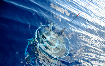
Scientists Use "ESP" to Track Harmful Algae
New Environmental Sample Processor could transform ocean monitoring
A “red tide” of blooming algae stretched more than 20 miles along the coast near La Jolla, Calif., in spring 1995. Blooms can be harmless, such as this one (the dinoflagellate Noctiluca scintillans), but blooms of some algae, including Alexandrium, can harm human health, coastal economies, and marine ecosystems. Algal blooms occur naturally, but have become much more common in recent years, sometimes due to human activities that put excess nutrients into the water. (Photo courtesy of Peter Franks, Scripps Institution of Oceanography)
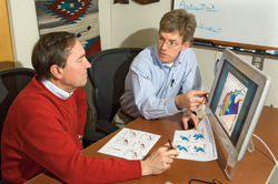
WHOI biologist Don Anderson (left) and oceanographer Dennis McGillicuddy review the results of a computer simulation of the 2008 harmful algae season in New England waters. The model successfully predicted a large regional outbreak of harmful algae that materialized later in the spring. (Photo by Tom Kleindinst, Woods Hole Oceanographic Institution)
WHOI researcher Bruce Keafer inspects the new ESP instrument before its spring 2011 deployment. McLane Research Laboratories in Falmouth, Mass., built the first ESP for this project, and plans to build five more. (Photo by Tom Kleindinst, Woods Hole Oceanographic Institution)
Researchers in biologist Don Anderson’s lab are celebrating a new arrival—a gleaming, 3-foot-high robotic instrument that promises to revolutionize how scientists detect and study the ocean’s tiny but troublesome inhabitants: harmful algae.
Moored at sea, the new instrument, called the Environmental Sample Processor, or ESP, samples seawater, filters out cells, and breaks them apart to release their DNA and telltale chemicals. It rapidly analyzes the DNA and specific chemicals to identify and count cells living in the ocean, and transmits the information in real time to scientists ashore, said Anderson, a senior scientist at Woods Hole Oceanographic Institution (WHOI).
The ESP will be placed off New England's coast in spring 2011 and will act as both observatory and early-warning system, alerting researchers to the beginnings of blooms, or population explosions, of Alexandriumfundyense, a toxin-producing single-celled alga. Scientists now search for such harmful algal blooms (HABs) by chartering boats, taking water samples, and laboriously identifying and counting cells under a microscope. As a result, they can detect blooms only after they are already under way. The ESP will continuously monitor the water and detect blooms as they begin, days or weeks before current methods can.
The toxins concentrate in algae-eating shellfish and fish and can sicken marine mammals or people who eat those shellfish or fish. Shellfish are routinely tested for contamination, and when a bloom occurs, shellfishing beds are closed to prevent contaminated seafood from reaching New England markets or restaurants. In recent years, harmful algal blooms in the Gulf of Maine and along Cape Cod have repeatedly caused closures and income losses to shellfish farmers. Made in Falmouth
The ESP was developed over years by Chris Scholin, who was Anderson’s former graduate student in the MIT/WHOI Joint Program in Oceanography and is now president and chief executive officer of the Monterey Bay Aquarium Research Institute (MBARI). One of Anderson’s former postdoctoral researchers, Greg Doucette, who developed an ESP assay to detect toxins from another harmful algal species, will develop an assay for Alexandrium toxins for this ESP.
Currently, the ESP remains on Anderson’s lab bench, where it has been renamed “Chris” in honor of Scholin. Using seawater samples brought to the ESP, WHOI researcher Bruce Keafer has been operating the instrument and “learning its ways,” he said, before they place it on a mooring in spring 2011.
Although early models of the ESP were all built and used by MBARI researchers, the instrument at WHOI was built locally and is the first commercially built ESP. Next year's coastal ocean ESP placement will be the first long-term deployment on the East Coast, where it will provide the first fully remote observation of a seasonal Alexandrium cycle in New England waters.
An advance in marine monitoringThe complex instrument required equally complex arrangements to bring it to WHOI. The instrument in Anderson’s lab was built by McLane Research Laboratories in Falmouth, Mass., with a license from Spyglass Biosecurity, and with MBARI’s collaboration. It was purchased by the U.S. Environmental Protection Agency and loaned to Anderson for use in his HAB studies in conjunction with the Northeast Regional Association of Coastal Ocean Observing Systems and state/federal partnerships to protect human and ecological health.
Further support for this research itself is being provided by the National Science Foundation as part of the federal stimulus funding, the National Oceanic and Atmospheric Administration, and the National Institute of Environmental Health Sciences. McLane Laboratories will build five more ESPs in support of Anderson's plan to place them in strategic areas for Alexandrium detection along the Gulf of Maine coast.
But this is just the start. Researchers have used early ESP models to detect other toxic algal species, and ESPs can also be used for detecting bacteria and larval organisms in the ocean. “You could use it to monitor sewage outfalls or pollultion in harbors and beaches, for example,” Anderson said. “The developers even hope it can go into space one day."
Anderson's previous work on Alexandrium has been funded by NSF, NOAA, and Woods Hole Sea Grant, part of the NOAA Sea Grant College Program.
The Steven Berkeley Marine Conservation Fellowship
This fellowship was created by AFS in 2007 to honor the memory of Steven Berkeley, a dedicated fisheries scientist with a passionate interest in integrating the fields of marine ecology, conservation biology, and fisheries science to improve fisheries management. Berkeley was a long-time member of AFS and a member of the first Board of Directors of the Fisheries Conservation Foundation. The fellowship comprises a competitively based $10,000 award to a graduate student actively engaged in thesis research relevant to marine conservation. Research topics may address any aspect of conservation; a focus on fisheries issues is not required.
Greenpeace, via Agence France-Presse — Getty Images“Protection of Reefs Now!” reads a banner in Spanish unfurled by Greenpeace divers in the Gulf of Mexico. The group is helping to gather information on the condition of coral there.
Carbon dioxide emissions from man-made sources are causing the acidity level of the world’s oceans to rise at what is probably the fastest rate in 65 million years, threatening global fisheries that serve as an essential food source for billions of people, according to a new United Nations report.
Roughly 25 percent of the carbon dioxide generated by the combustion of fossil fuels enters the oceans, and as the gas dissolves in seawater it changes into carbonic acid. One result has been a rapid alteration in ocean chemistry that is already affecting marine organisms.
The acidity of the oceans has grown 30 percent since the beginning of the Industrial Revolution. At current emission rates, ocean acidity could be 150 percent higher by the end of the century, the report states.
Marine life and coral reefs have already shown vulnerability to rising levels of acidity, and the changes expected in coming decades are severe enough that they could have a serious impact on the ability of people around the world to harvest needed protein from the seas, according to Carol Turley, senior scientist at Britain’s National Oceanography Center and the lead author of the report.
“We need to start thinking about the risk to food security,” Dr. Turley said in a statement.
The report also warns that the rise in ocean acidity poses a severe threat to coral reefs, which are already under stress from pollution and the warming of oceans — a concern shared by a growing number of marine scientists.
Acidification could conceivably wipe out most of the world’s already ailing coral reefs within a generation or two, said John Veron, former chief scientist of the Australian Institute of Marine Science, in an essay posted this week on the Web site Yale Environment 360.
“The potential consequences of such acidification are nothing less than catastrophic,” Dr. Veron wrote.
As acidification continues, coral and marine organisms like shellfish will begin to suffer from osteoporosis — an inability to fix calcium into shells and other structures.
“No doubt different species of coral, coralline algae, plankton and mollusks will show different tolerances, and their capacity to calcify will decline at different rates,” Dr. Veron wrote. “But as acidification progresses, they will all suffer from some form of coralline osteoporosis.”
“The result will be that corals will no longer be able to build reefs or maintain them against the forces of erosion,” the article continues. “What were once thriving coral gardens that supported the greatest biodiversity of the marine realm will become red-black bacterial slime, and they will stay that way.”
Subject Area:Fish behavior and conservation engineering related to New England commercial marine fisheries
Salary: $20,000 - $22000/year, plus tuition and fees
Closing: Until filled
Responsibilities: Conduct research on fish behavior and conservation engineering related to commercial marine capture fisheries, including devising means and methods to reduce bycatch and seabed impact of fishing operations in groundfish, pelagic and shellfish fisheries in Northeastern USA.
The student will develop a dissertation based on laboratory and field experiments to understand fish behavior, fishing gear performance, and analytical methods for evaluation of bycatch reduction devices. Student is expected to present at meetings and publish in peer-reviewed journals.
Qualifications: MS degree in ecology, fisheries, or engineering. Meeting basic requirements for admission to the inter-campus graduate School of Marine Sciences of University of Massachusetts. Strong skills in statistical analysis and field methods are desirable. Student will be required to carry out research onboard fishing and/or research vessels.
Start date: As soon as possible. Qualified student may start as a paid technical assistant before fall 2011 course begins.
Contact: Please email a statement of interest, CV, unofficial copies of transcripts and GRE together with any publications and a list of 3 professional references to Dr. Pingguo He.
Pingguo He (PhD)
Associate Professor - Fisheries
School for Marine Science and Technology
University of Massachusetts Dartmouth
706 South Rodney French Boulevard, New Bedford MA 02744
You would measure time the measureless and the immeasurable.
You would adjust your conduct and even direct the course of your spirit according to hours and seasons.
Of time you would make a stream upon whose bank you would sit and watch its flowing.
Yet the timeless in you is aware of life's timelessness,
And knows that yesterday is but today's memory and tomorrow is today's dream.
And that that which sings and contemplates in you is still dwelling within the bounds of that first moment which scattered the stars into space.
Who among you does not feel that his power to love is boundless?
And yet who does not feel that very love, though boundless, encompassed within the centre of his being, and moving not from love thought to love thought, nor from love deeds to other love deeds?
And is not time even as love is, undivided and spaceless?
But if in your thought you must measure time into seasons, let each season encircle all the other seasons,
And let today embrace the past with remembrance and the future with longing.
Apocalypse forestalled: Why all the world’s fisheries aren’t collapsing
By Ray Hilborn, professor of Aquatic and Fishery Sciences, University of Washington
If you have paid any attention to the conservation literature or science journalism over the last five years, you likely have gotten the impression that our oceans are so poorly managed that they soon will be empty of fish — unless governments order drastic curtailment of current fishing practices, including the establishment of huge no-take zones across great swaths of the oceans.
To be fair, there are some places where such severe declines may be true. A more balanced diagnosis, however, tells a different story — one that still requires changes in some fishing practices, but that is far from alarmist. But this balanced diagnosis is being almost wholly ignored in favor of an apocalyptic rhetoric that obscures the true issues fisheries face as well as the correct cures for those problems.
Where the apocalyptic rhetoric comes from
To get the storyline correct, it is important to go back to the sources of the apocalyptic rhetoric. In 2006, a paper was published by Boris Worm in Science (Worm et al. 2006) that received enormous press coverage. It argued that, if current trends continued, all fish stocks would collapse by 2048. Worm and his coauthors concluded their paper with the following sentence: “Our analyses suggest that business as usual would foreshadow serious threats to global food security, coastal water quality, and ecosystem stability, affecting current and future generations.”
Others joined in, chief among them Daniel Pauly, who rang and continues to ring the apocalyptic note. “There are basically two alternatives for fisheries science and management: one is obviously continuing with business as usual…,” wrote Pauly in 2009 (Pauly 2009a). “This would lead, in addition to further depletion of biodiversity, to intensification of ‘fishing down marine food webs,’ which ultimately involves the transformation of marine ecosystems into dead zones.”
It might surprise you to learn Pauly’s views are not universally held among scientists. Indeed, these papers exposed a deep divide in the marine science community over the state of fish stocks and the success of existing fisheries management approaches. Numerous critiques of the apocalyptic stance were published after the 2006 paper, suggesting that Worm et al. had greatly exaggerated the failings of “business as usual.” For instance, Steve Murawski, director of scientific programs and chief science advisor, defended the U.S. fisheries management system and pointed out that the proportion of stocks overfished in the U.S. was declining, not increasing (Murawski et al. 2007).
The real question: Are current fishing practices decimating stocks…or rebuilding them?
No one disagrees on our goals for the world’s fisheries stocks — we need higher fish abundances. The arguments are largely about where we are now and how we will get to higher fish abundance and lower fishing pressure. Are current fisheries management systems working to decimate fish stocks…or rebuild them? Do we need large areas of the oceans closed to fishing to assure sustainable seafood supply? Daniel Pauly says yes to the latter question: “This transformation,” he writes, “would also require extensive use of ocean zoning and spatial closures, including no-take marine protected areas (MPAs). Indeed, MPAs must be at the core of any scheme intending to put fisheries on an ecologically sustainable basis” (Pauly 2009a).
In an attempt to resolve this dispute, Boris Worm and I several years ago organized a set of four meetings, sponsored by the National Center for Ecological Analysis and Synthesis (NCEAS), in which we assembled a database on abundance as measured by fisheries agencies and research surveys. Participants included several of the authors of the 2006 paper as well as several people from national fisheries management agencies.
The results were published in Science in 2009 (Worm et al. 2009), and showed that, while the majority of stocks were still below target levels, fishing pressure had been reduced in most ecosystems (for which we had data) to below the point that would assure long-term maximum sustainable yield of fish from those ecosystems.
About 30 percent of the stocks would currently be classified as overfished — but, generally, fishing pressure has been reduced enough that all but 17 percent of stocks would be expected to recover to above overfished thresholds if current fishing pressure continues. In the United States, there was clear evidence for the rebuilding of marine ecosystems and stock biomass. The idea that 70 percent of the world’s fish stocks are overfished or collapsed and that the rate of overfishing is accelerating (Pauly 2007) was shown by Worm et al. (2009) and FAO (2009) to be untrue.
The Science paper coming out of the NCEAS group also showed that the success in reducing fishing pressure had been achieved by a broad range of traditional fisheries management tools — including catch-and-effort limitation, gear restrictions and temporary closed areas. Marine protected areas were an insignificant factor in the success achieved.
The database generated by the NCEAS group and subsequent analysis has shown that many of the assumptions fueling the standard apocalyptic scenarios painted by the gloom-and-doom proponents are untrue:
For instance, the widespread notion that fishermen generally sequentially deplete food webs (Pauly et al. 1998) — starting with the predators and working their way down — is simply not supported by data.
Declining trophic level of fishery landings is just as often a result of new fisheries developing rather than old ones collapsing (Essington et al. 2006).
Catch data also show that fishing patterns are driven by economics, with trophic level a poor predictor of exploitation history (Sethi et al. 2010).
Furthermore, the mean trophic level of marine ecosystems is unrelated to (or even negatively correlated with) the trophic level of fishery landings (Branch et al. 2010).
And the oft-cited assessment that the large fish of the oceans were collapsed by 1980 (Myers and Worm 2003) is totally inconsistent with the database we have assembled — for instance, world tuna stocks in total are at present well above the level that would produce maximum sustained yield, except bluefin tuna and some other billfish that are depleted (Hutchings 2010).
Nevertheless, many in the marine conservation community appear unwilling to accept these results, continue to insist that all fish may be gone by 2048, and use declining catches in fisheries where regulations have reduced catches as indications of stock collapse.
No one argues that all fisheries are well-managed, and so far we do not have abundance estimates for many parts of the world, especially Asia and Africa. Using the catch-based methods of Worm et al. (2006) and Pauly, these areas appear to have fewer stock collapses and overfished stocks than in the areas for which we have abundance data. However, we do not know if these areas have been reducing exploitation rates or if they are still increasing.
Finally, in places without strong central government control of fishing, there is broad agreement that community-based co-management can be effective. For these fisheries, management tools are very different than those used for industrial fishery stocks, and MPAs are here often a key ingredient. The lessons from the Worm et al. (2009) paper about what works to rebuild fish stocks are applicable to industrial fisheries, but probably not to the small-scale fisheries that support many fishing communities.
Stop the alarmism and build off what’s working
There is considerable room for policy debate about where we want to be in the trade-off between yield and environmental impact of fishing. There is no denying that sustainable fishing changes ecosystems, and that different societies will almost certainly make different choices about how much environmental change they will accept in return for sustainable food production. But science cannot provide the answers for this debate; it can only evaluate the trade-offs.
My perspective is that we need to treat fisheries like medical diagnoses. We must identify which fisheries are in trouble and find the cures for those individual fisheries. The evidence is strong that we can and are rebuilding stocks in many places. Let us accept that progress and identify the problem stocks and how to fix them.
Apocalyptic assertions that fisheries management is failing are counter-productive — not only because these assertions are untrue, but because they fail to recognize the long, hard work of fishery managers, scientists and stakeholders in the many places where management is working. While the gloom-and-doom advocates have been attracting public attention and press coverage, thousands of people — decried by Pauly (2009b) as agents of the commercial fishing interests — have worked through years of meetings and painful catch and effort reductions to lower fishing pressure and successfully rebuild fisheries.
References Branch, T. A., R. Watson, E.A. Fulton, S. Jennings, C.R. McGilliard, G. T. Pablico, and D. Ricard. 2010. The trophic fingerprint of marine fisheries. Nature 468:431-435. doi:10.1038/nature09528.
Essington, T. E., A. H. Beaudreau and J. Wiedenmann. 2006. Fishing through marine food webs. Proceedings of the National Academy of Sciences 103:3171-3175.
FAO. 2009. State of World Fisheries and Aquaculture 2008. FAO: Rome.
Hutchings, J. A., C. Minto, D. Ricard, J.K. Baum, and O.P. Jensen. 2010. Trends in abundance of marine fishes. Can. J. Fish. Aquat. Sci. 67:1205-1210.
Murawski, S., R. Methot, and G. Tromble. 2007. Biodiversity loss in the ocean: How bad is it? Science 316:1281-1281.
Myers, R. A. and B. Worm. 2003. Rapid worldwide depletion of predatory fish communities. Nature 423: 280-283.
Pauly, D. 2007. The Sea Around Us Project: Documenting and communicating global fisheries impacts on marine ecosystems. Ambio 36:290-295.
Pauly, D. 2009a. Beyond duplicity and ignorance in global fisheries. Scientia Marina 73:215-224.
Pauly, D. 2009b. Aquacalypse Now: The End of Fish. The New Republic 240:24-27.
Pauly, D., V. Christensen, J. Dlasgaard, R. Froese, and F. Torres Jr. 1998. Fishing down marine food webs. Science279:860-863.
Sethi, S. A., T. A. Branch and R. Watson. 2010. Global fishery development patterns are driven by profit but not trophic level. Proceedings of the National Academy of Sciences 107:12163-12167.
Worm, B., E. B. Barbier, N. Beaumont, J.E. Duffy, C. Folke, B.S. Halpern, J.B.C. Jackson, H.K. Lotze, F. Micheli, S.R. Palumbi, E. Sala, K.A. Selkoe, J.J. Stachowicz and R. Watson. 2006. Impacts of biodiversity loss on ocean ecosystem services. Science 314:787-790.
Worm, B., R. Hilborn, J.K. Baum, T.A. Branch, J.S. Collie, C. Costello, M.J. Fogarty, E.A. Fulton, J.A. Hutchings, S. Jennings, O.P. Jensen, H.K. Lotze, P.M. Mace, T.R. McClanahan, C. Minto, S.R. Palumbi, A. Parma, D. Ricard, A.A. Rosenberg, R. Watson, and D. Zeller. 2009. Rebuilding Global Fisheries. Science 325:578-585.


