Search This Blog

Sunday, April 10, 2011

West Antarctic Warming Triggered by Warmer Sea Surface in Tropical Pacific


ScienceDaily (Apr. 10, 2011) — The Antarctic Peninsula has warmed rapidly for the last half-century or more, and recent studies have shown that an adjacent area, continental West Antarctica, has steadily warmed for at least 30 years, but scientists haven't been sure why.

New University of Washington research shows that rising sea surface temperatures in the area of the Pacific Ocean along the equator and near the International Date Line drive atmospheric circulation that has caused some of the largest shifts in Antarctic climate in recent decades.

The warmer water generates rising air that creates a large wave structure in the atmosphere called a Rossby wave train, which brings warmer temperatures to West Antarctica during winter and spring.

Antarctica is somewhat isolated by the vast Southern Ocean, but the new results "show that it is still affected by climate changes elsewhere on the planet," said Eric Steig, a UW professor of Earth and space sciences and director of the UW Quaternary Research Center.

Steig is the corresponding author of a paper documenting the findings that is being published April 10 in the journal Nature Geoscience. The lead author is Qinghua Ding, a postdoctoral researcher in the UW Quaternary Research Center. Co-authors are David Battisti, a UW atmospheric sciences professor, and Marcel Küttel, a former UW postdoctoral researcher now working in Switzerland.

The scientists used surface and satellite temperature observations to show a strong statistical connection between warmer temperatures in Antarctica, largely brought by westerly winds associated with high pressure over the Amundsen Sea adjacent to West Antarctica, and sea surface temperatures in the central tropical Pacific Ocean.

They found a strong relationship between central Pacific sea-surface readings and Antarctic temperatures during winter months, June through August. Though not as pronounced, the effect also appeared in the spring months of September through November.

The observed circulation changes are in the form of a series of high- and low-pressure cells that follow an arcing path from the tropical Pacific to West Antarctica. That is characteristic of a textbook Rossby wave train pattern, Ding said, and the same pattern is consistently produced in climate models, at least during winter.

Using observed changes in tropical sea surface temperatures, the researchers found they could account for half to all of the observed winter temperature changes in West Antarctica, depending on which observations are used for comparison.

"This is distinct from El Niño," Steig said. That climate phenomenon, which affects weather patterns worldwide, primarily influences sea-surface temperatures farther east in the Pacific, nearer to South America. It can be, but isn't always, associated with strong warming in the central Pacific.

Steig noted that the influence of Rossby waves on West Antarctic climate is not a new idea, but this is the first time such waves have been shown to be associated with long-term changes in Antarctic temperature.
The findings also could have implications for understanding the causes behind the thinning of the West Antarctic Ice Sheet, which contains about 10 percent of all the ice in Antarctica.

Steig noted that the westerly winds created by the high pressure over the Amundsen Sea pushes cold water away from the edge of the ice sheet and out into the open ocean. It is then replaced by warmer water from deeper in the ocean, which is melting the seaward edge of the ice sheet from below.

The work was funded by the National Science Foundation.


Journal Reference:
  1. Qinghua Ding, Eric J. Steig, David S. Battisti, Marcel Küttel. Winter warming in West Antarctica caused by central tropical Pacific warming. Nature Geoscience, 2011; DOI: 10.1038/ngeo1129
Thursday, April 7, 2011

Climate Change Poses Major Risks for Unprepared Cities

 
Fast-growing urban areas most likely to feel the heat
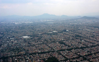
Photo of Mexico City.
People in urban areas like Mexico City are especially at risk from the effects of climate change.

April 7, 2011

Cities worldwide are failing to take necessary steps to protect residents from the likely impacts of climate change, even though billions of urban dwellers are vulnerable to heat waves, sea level rise and other changes associated with warming temperatures.

A new examination of urban policies by Patricia Romero Lankao at the National Center for Atmospheric Research (NCAR) in Boulder, Colo., in conjunction with an international research project on cities and climate change, warns that many of the world's fast-growing urban areas, especially in developing countries, will likely suffer disproportionately from the impacts of changing climate.

Her work also concludes that most cities are failing to reduce emissions of carbon dioxide and other greenhouse gases that affect the atmosphere. "Climate change is a deeply local issue and poses profound threats to the growing cities of the world," says Romero Lankao. "But too few cities are developing effective strategies to safeguard their residents."

Romero Lankao's studies appear this month in a special issue of Current Opinion in Environmental Sustainability and in a synthesis article in an upcoming issue of European Planning Studies. The research was conducted in association with the United Nations Human Settlements Programme (UN-HABITAT) and funded by the National Science Foundation (NSF), NCAR's sponsor.

"Cities are major sources of greenhouse gases, yet at the same time urban populations are likely to be among those most severely affected by future climate change," says Sarah Ruth, program director in NSF's Division of Atmospheric and Geospace Sciences, which funds NCAR.

"The findings highlight ways in which city-dwellers are particularly vulnerable, and suggest policy interventions that could offer immediate and longer-term benefits."

Romero Lankao, a sociologist specializing in climate change and urban development, surveyed policies in cities worldwide while drawing on a number of recent studies of climate change and cities.

She concluded that cities are falling short in two areas: preparing for the likely impacts of climate change and cutting their own greenhouse gas emissions by reducing fossil fuel use.

With more than half the world's population living in cities, scientists are increasingly focusing on the potential impacts of climate change on these areas.

The locations and dense construction patterns of cities often place their populations at greater risk for natural disasters, including those expected to worsen with climate change.

Potential threats associated with climate include storm surges that can inundate coastal areas and prolonged hot weather that can heat heavily paved cities more than surrounding areas.

The impacts of such natural events can be magnified in an urban environment. For example, a prolonged heat wave can exacerbate existing levels of air pollution, causing widespread health problems.

Poorer neighborhoods that may lack basic facilities such as reliable sanitation, drinking water or a dependable network of roads, are especially vulnerable to natural disasters.

Moreover, populations are increasing most quickly in small- and medium-sized urban areas, which often lack the services and infrastructure to manage the rapid influx, according to Romero Lankao.

The number of urban residents worldwide has quadrupled since 1950, and cities are continuing to grow rapidly, especially in developing nations.

Romero Lankao cites projections that, by 2020, there will be more than 500 urban areas with 1 million or more residents. Many residents in poorer countries live in substandard housing without access to reliable drinking water, roads and basic services. Neighborhoods sometimes spring up on steep hillsides or floodplains, leaving them vulnerable to storms.

But even on the heels of deadly catastrophes that scientists say will become more common with climate change, such as flash floods in Rio de Janeiro or heat waves in Europe, leaders are often failing to reinforce their defenses against natural disasters.

Romero Lankao cites three reasons for the failure to prepare: fast-growing cities are overwhelmed with other needs, city leaders are often under pressure to downplay the need for health and safety standards in order to foster economic growth and climate projections are rarely fine-scale enough to predict impacts on individual cities.

"Local authorities tend to move towards rhetoric rather than meaningful responses," Romero Lankao writes. "What is at stake, of course, is the very existence of many human institutions, and the safety and well-being of masses of humans."

Cities are also failing in many cases to curb their own emissions of greenhouse gases, the study finds. Instead of imposing construction standards that could reduce heating and air conditioning needs or guiding development to emphasize mass transit and reduce automobile use, many local governments are taking a hands-off approach.

"Cities can have an enormous influence on emissions by focusing on mass transit systems and energy efficient structures," Romero Lankao says. "But local leaders face pressures to build more roads and relax regulations that could reduce energy use."

The study also cites efforts in some cities to reduce emissions as part of a larger strategy to ease traffic and other problems.

For example, central London's Congestion Charging Zone is intended to encourage more use of mass transit. And several Latin American cities, such as Curitiba, Brazil, and Bogota, Colombia, are integrating new development with mass transit systems.

As cities attempt to meet the needs of their low-income residents, some strategies-including moving residents away from risk-prone areas and improving housing and services-may also improve their readiness for a changing climate.

"As hubs of development, cities have shown that they can become sources of innovation," Romero Lankao says.

"The good news is that policymakers can discover ways to improve sanitation, health and safety as they try to reduce emissions and adapt to climate impacts."

Tuesday, April 5, 2011

Glaciers in Chile 'melt at fastest rate in 350 years'

Upsala glacier San Rafael Glacier in Patagonia, one of the 270 glaciers included in this study, has retreated about 8km since the peak of the 'Little Ice Age'.
 
Melting mountain glaciers are making sea levels rise faster now than at any time in the last 350 years, according to new research. Universities at Aberystwyth, Exeter and Stockholm looked at longer timescales than usual for their study.They mapped changes in 270 of the largest glaciers between Chile and Argentina since the "Little Ice Age".

Studies showed glaciers have lost volume on average "10 to 100 times faster" in the last 30 years. The rapid melt rate is linked to their contribution to global sea level. The new research was published in the journal Nature Geoscience on Sunday. Their survey centered on remotely sensed images of outlet glaciers of the south and north Patagonian icefields, but used longer timescales than previous studies.

Upsala glacier in Patagonia Satellite image of Upsala Glacier in Patagonia, which has retreated about 13km since 1750.
 
The glaciers straddle the Andes, on the border between Chile and Argentina. The northern icefield extends for nearly 200 km and covers a surface of 4,200 square km, while the southern icefield is more than 350km long, covering 13,000 square km. 

The scientists mapped changes in the position of the glaciers since the "Little Ice Age". This took place around 1870 for the north icefield and around 1650 for the southern icefield, the last time that they were much larger in the recent past.

Lead author, Professor Neil Glasser of Aberystwyth University, said: "Previous estimates of sea-level contribution from mountain glaciers are based on very short timescales. "They cover only the last 30 years or so when satellite images can be used to calculate rates of glacier volume change. "We took a different approach by using a new method that allows us to look at longer timescales.
 
'Above-average'

"We knew that glaciers in South America were much bigger during the Little Ice Age so we mapped the extent of the glaciers at that time and calculated how much ice has been lost by the retreat and thinning of the glaciers." Their calculations showed that in recent years the mountain glaciers have rapidly increased their melt rate and thus their contribution to global sea level.

Dr Stephen Harrison of the University of Exeter, added: "The work is significant because it is the first time anyone has made a direct estimate of the sea-level contribution from glaciers since the peak of the industrial revolution (between 1750-1850). "

He said their results showed that estimates taken a decade ago of rates of glacier contribution to sea-level rise are "well above" the long-term averages, which cover 1650/1750 to 2010 and 1870-2010.

Monday, March 21, 2011

King crabs invade Antarctica


Sven Thatje has been predicting an invasion of deep-water crabs into shallow Antarctic waters for the past several years.

A crab in the Bellingshausen Sea.
(
Florida Tech
)

Courtesy of Richard B. Aronson / Florida Tech - A crab in the Bellingshausen Sea.

But the biologist and his colleagues got their first look at the march of the seafloor predators while riding on an icebreaker across frozen Antarctic seas this winter.

The ship towed a robot sub carrying a small digital camera that filmed the seafloor below. It caught images of bright red king crabs up to 10 inches long, moving into an undersea habitat of creatures that haven’t seen sharp teeth or claws for the past 40 million years.

“There were hundreds,” Thatje said in an interview on board the Swedish icebreaker Oden, which docked at the main U.S. base in Antarctica, McMurdo Station, after a two-month research cruise. “Along the western Antarctica peninsula, we have found large populations over 30 miles. It was quite impressive.”

Thatje, an evolutionary biologist at the University of Southampton in England and chief scientist on the cruise, is part of a U.S.-Swedish team of marine researchers who are trying to figure out where, when and how fast this invasion is occurring. King crabs, of which there are 13 species, live in the deep waters off Alaska and Russia and across the Southern Ocean in the waters off New Zealand, Chile and Argentina. But here in Antarctica, crabs haven’t been able to survive because, until now, it’s been too cold. As a result, many bottom-dwelling creatures such as mussels, brittle stars and sea urchins have not developed any defenses against the crabs.

What’s happened is that the waters around the Antarctic peninsula have begun to get warmer. The air temperature has jumped almost 11 degrees Fahrenheit since the 1950s, and the average ocean temperature has increased by one degree over the same period. That slight change in water temperature has lowered a physiological barrier that had previously kept the crabs in check, Thatje said.

When the water is too cold — as it has been along the shallow waters of the Antarctic continental shelf — crabs can’t remove magnesium from their blood. Magnesium is a common mineral in seawater, and if they can’t get rid of it, it causes a narcotic effect that stops them from moving enough to survive.

Some scientists say the magnesium barrier may soon fall, as global climate change continues to affect wildlife at the polar regions.

The lack of clawed, beaked or toothed predators has led to a thick seafloor canopy of sorts, much like a submarine jungle comprising flowery feather stars, tube worms and squirming sea spiders along with clams and mussels.

As they sift through more than 120,000 digital images from their expedition, Thatje and other researchers are looking for evidence that crabs are preying on these creatures.

“The Antarctic shelf communities are quite unique,” Thatje said. “This is the result of tens of millions of years of evolution in isolation.”

The crab research team is analyzing the images of the seafloor, looking for clues into whether the crabs will invade and then leave or permanently colonize the shallow areas. Will their presence destroy the existing community or simply alter it? Previous cruises had spotted only one or two crabs, but now scientists are seeing entire populations, according to Richard Aronson, biology professor at the Florida Institute of Technology and co-investigator on the project, along with James McClintock of the University of Alabama at Birmingham.

The crabs are moving from the deep ocean, up the continental slope to the shallower shelf areas. Unlike most areas of the world, the shallower waters on the Antarctic continental shelf are actually slightly colder than the deeper waters of the Southern Ocean. That’s because of a clockwise current of water called the Antarctic circumpolar current.

That flow of cold water keeps Antarctic marine life — especially the bottom-dwelling creatures — isolated. There are no sharks, rays or fish with bony jaws, for example, in Antarctica.

“If you look at the warming trends on the peninsula, you would expect that the crabs would come back in 40 or 50 years,” Aronson said from his office in Melbourne, Fla. “But, boom, they’re already here.”

Not all experts agree that the crabs are destined to wreak havoc on the sea bottom. David Clarke, a marine ecologist at the British Antarctic Survey, said that the seawater temperature changes may be occurring on the surface of the ocean but that they’re too small to affect animals living on the bottom.

Clarke studies colonial animals in Antarctica, such as sponges and corals, and how they fit into the ecosystem. He said not enough is known about existing crab populations — where they live and how long they have been there — to declare that climate change is causing an invasion.

At the same time, he agrees with the Swedish and U.S. researchers that there are rapid changes underway in Antarctica, especially on the Western Antarctic peninsula, a thumb of land that juts northward to the bottom of South America. There’s less sea ice, for example, on the waters of the peninsula. That is causing problems for the penguins and seals that depend on sea ice for food and shelter.

“Yes, there is some cause for concern in that the rate of [environmental] change is greater than has been the case in recent millions of years,” Clarke said. “Obviously, for animals to tolerate or adapt to things in a very short period of time is going to be tricky.”

Tuesday, March 15, 2011

Japan quake shifts Antarctic glacier

March 15, 2011 by Anil Ananthaswamy


The major earthquake that hit Japan on Friday caused a massive ice stream in Antarctica to momentarily speed up.

As the surface seismic waves generated by the quake travelled around the world, they appear to have given the Whillans ice stream in West Antarctica a nudge, causing it to shift by about half a metre.

The movement was picked up by Jake Walter of the University of California, Santa Cruz, and his colleagues, who monitor the glacier remotely from California. They say the event is an "interesting insight", but are not suggesting it will destabilise the West Antarctic Ice Sheet in any significant way.

The Whillans ice stream drains ice from the West Antarctic Ice Sheet into the Ross Ice Shelf. Since 2007, Walter and colleagues have been using GPS field stations on the ice sheet to monitor its movements. They have shown that the ice stream speeds up twice a day in slip events which last about 30 minutes.

The glacier normally creeps along at an average speed of about 1 metre per day. But during a slip event, it slides almost half a metre in one go. The sudden slips are related to the tides, and are strong enough to generate seismic waves that are recorded by stations at the South Pole and the Antarctic Dry Valleys (Journal of Geophysical Research, DOI: 10.1029/2010JF001754).


Slipping glacier


Now it looks like the magnitude 9.0 earthquake that shook Japan last Friday caused the glacier to slip in a similar way.

When Walter and his colleagues were analysing GPS data from the ice stream on Monday, they noticed that one slip event had happened earlier than expected. Further analysis revealed that it happened exactly when surface seismic waves generated by the Japanese earthquake would have hit Antarctica.

Large earthquakes are known to create seismic waves which can circle the planet several times before dying down.

"The Chile earthquake from last year also had a similar effect" on the Whillans ice stream, Walter told New Scientist. "It's an interesting insight into how large earthquakes might affect glacier motion."

Walter and colleagues now want to examine data from other large earthquakes to see if any others are linked to slip events of the Whillans ice stream.

Monday, March 14, 2011

In the North Atlantic, Oceanic Currents Play a Greater Role in the Absorption of Carbon Than Previously Thought


ScienceDaily (Mar. 9, 2011) — The ocean traps carbon through two principal mechanisms: a biological pump and a physical pump linked to oceanic currents. A team of researchers from CNRS, IRD, the Muséum National d'Histoire Naturelle, UPMC and UBO (1) have managed to quantify the role of these two pumps in an area of the North Atlantic. Contrary to expectations, the physical pump in this region could be nearly 100 times more powerful on average than the biological pump. By pulling down masses of water cooled and enriched with carbon, ocean circulation thus plays a crucial role in deep carbon sequestration in the North Atlantic.


These results are published in the Journal of Geophysical Research.

The ocean traps around 30% of the carbon dioxide emitted into the atmosphere through human activity and represents, with the terrestrial biosphere, the main carbon sink. Much research has been devoted to understanding the natural mechanisms that regulate this sink. On the one hand, there is the biological pump: the carbon dioxide dissolved in the water is firstly used for the photosynthesis of phytoplankton, microscopic organisms that proliferate in the upper layer of the ocean. The food chain then takes over: the phytoplankton is eaten by zooplankton, itself consumed by larger organisms, and so on. Cast into the depths in the form of organic waste, some of this carbon ends its cycle in sediments at the bottom of the oceans. This biological pump is particularly effective in the North Atlantic, where a spectacular bloom of phytoplankton occurs every year. On the other hand, there is the physical pump which, through oceanic circulation, pulls down surface waters containing dissolved carbon dioxide towards deeper layers, thereby isolating the gas from exchanges with the atmosphere.

On the basis of data collected in a specific region of the North Atlantic during the POMME (2) campaigns, the researchers were able to implement high-resolution numerical simulations. They thus carried out the first precise carbon absorption budget of the physical and biological pumps. They succeeded, for the first time, in quantifying the respective proportions of each of the two mechanisms. Surprisingly, their results suggest that in this region of the North Atlantic the biological pump would only absorb a minute proportion of carbon, around one hundredth. The carbon would thus be trapped mainly by the physical pump, which is almost one hundred times more efficient. At this precise location, oceanic circulation pulls down the carbon, in dissolved organic and inorganic form, to depths of between 200 and 400 meters, together with the water masses formed at the surface.

The key role of the physical pump in the North Atlantic had never been quantified before. Its importance raises numerous questions: how long does the carbon transported by the physical pump remain trapped at depth before being driven back to the surface by the reverse mechanism? Is this proportion between the biological pump and the physical pump observed in other oceanic regions of the planet? And, last but not least, how will this mechanism evolve with climate change, which affects both the physical mechanism and the biological mechanism?

*Notes* (1) The laboratories concerned are: the Laboratoire d'Océanographie et du Climat: Expérimentations et Approches Numériques (LOCEAN, UPMC/CNRS/MNHN/IRD) and the Laboratoire des Sciences de l'Environnement Marin (LEMAR, CNRS/IRD/UBO).

(2) The POMME program (Multidisciplinary Meso-Scale Ocean Program) lasted from August 2000 to October 2001. In one year, four oceanographic campaigns were conducted in a specific area of the North Atlantic.

More than one hundred researchers and engineers were involved in this novel program, supported by several French institutions (CNRS, SHOM, Ifremer, Météo-France).


Journal Reference:
  1. P. Karleskind, M. Lévy, L. Memery. Subduction of carbon, nitrogen, and oxygen in the northeast Atlantic. Journal of Geophysical Research, 2011; 116 (C2) DOI: 10.1029/2010JC006446

Wednesday, March 9, 2011

Ice Loss Accelerates in Greenland, Antarctica, NASA Study Finds


Greenland and Antarctica’s ice sheets are shrinking more quickly, suggesting United Nations projections for sea-level rise are too conservative, a U.S. National Aeronautics and Space Administration-funded study said. 

From 1992 to 2009, the two regions lost on average 36.3 billion tons more ice every year than the previous year, scientists led by Eric Rignot at NASA’s Jet Propulsion Laboratory in Pasadena, California, said in a study in the Geophysical Research Letters journal. The researchers said they linked two independent sets of measurements to validate them. 

Continuing the trend may raise oceans 15 centimeters (6 inches) from 2010 to 2050, and by 56 centimeters by 2100, the study said. That’s more than what was factored into the 2007 projection by the UN’s Intergovernmental Panel on Climate Change for seas to rise 18 to 59 centimeters by 2100. 

“If present trends continue, sea level is likely to be significantly higher than levels projected by the United Nations,” Rignot said in a statement e-mailed late yesterday by NASA. “Our study helps reduce uncertainties.” 

The UN prediction also includes the expansion of water with warmer temperatures and the melting of mountain glaciers and smaller ice caps. 

The researchers said their 2050 forecast has a margin of error of 2 centimeters. Melting from mountain glaciers and smaller ice caps would add 8 centimeters to the sea level increase. The expansion of water as temperatures rise would add 9 centimeters, the researchers said. 

They warned their 2100 figure can’t be considered a projection because of “considerable uncertainty in future acceleration of ice sheet mass loss.” 

‘Surprising’ Acceleration 

The IPCC in 2007 said Greenland and Antarctica contributed a combined 0.42 millimeters a year to sea level rise from 1993 through 2003. That’s just over half the 0.77-millimeter contribution from mountain glaciers and smaller ice caps, and a quarter of the 1.6-millimeter rise as a result of water expanding with warmer temperatures. 

The North Atlantic island and southern continent now contribute more than mountain glaciers and ice caps, according to the NASA study. The researchers cited another paper that put the ice loss of the glaciers and ice caps at 402 billion tons in 2006, compared with the 475 billion tons from Greenland and Antarctica in the same year -- equivalent to 1.3 millimeters of sea level rise. The acceleration in ice loss is three times greater than for mountain glaciers, they wrote. 

“That ice sheets will dominate future sea level rise is not surprising -- they hold a lot more ice mass than mountain glaciers,” said Rignot, also a researcher at the University of California, Irvine. “What is surprising is this increased contribution by the ice sheets is already happening.” 

Utrecht University in the Netherlands and the National Center for Atmospheric Research in Boulder, Colorado, also contributed to the research. The scientists correlated different sets of satellite, radar and climate modeling data to produce the study.